Whose Beach is it, anyway?


An Irishman walks into a bar and sees two guys duking it out. During a lull, he asks "Is this a private fight, or can anybody get in on it?" I'm not Irish, but when people threaten to steal from me, I can be.
Admittedly, I hadn't been paying much attention to the boisterous boat parties in front of our Seabreeze Beach house every warm, sunny Saturday and Sunday afternoon. My partner Terry is feisty enough to handle that on her own. Especially after two party-prepped and pre-lubed debutantes took a shortcut through our front yard to get to the boats last year, physically pushing her aside while proclaiming "It's a beach, bitch!" Yep, she's up to that. Me, I just stayed away most weekends. Then the Restore Public Waters in Rochester alliance posted their land grab intentions on the internet:
"We will also be formally filing to show the actual property lines of the beach, showing once and for all where the property lines are; which will expand the public beach a minimum of 20 feet from the water's edge for the entire stretch of the beach, and in many areas as much as 100 feet of additional public beach!"
"Yes, you will once again be legally allowed to walk the beach without being harassed by the residents or the government!"
Really, guys? Hasn't your attorney told you that the war on private beachfront property has been going on for centuries, and that even when the Crown was still ruling the Colonies, the courts have consistently sided with the property owners? Besides, nothing is ever "once and for all," or we wouldn't need so many lawyers.
There's more. On July 2, 2012, the newly formed Restore Public Water Rights in Rochester Inc. appealed to Commissioner Rose Harvey of the NYS Office of Parks, Recreation, and Historic Preservation. Their letter included the following:
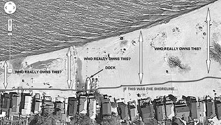
"The "private" beach didn't exist before the creation of the Irondequoit Bay Outlet piers in 1984. This allowed the sand to deposit along the shoreline, increasing the beachfront proportionally with respect to the proximity of the jettys. This picture depicts the approximate shoreline in red, as it appreared before the bay outlet jettys were constructed."
"As you can see, the shore was historically located very close to the lakefront cottages (not much beach at all). We believe it's also surveyed accordingly on the vast majority of the beachfront property surveys. Circled in blue is a former dock of one of the beachfront businesses; before the sand artificially accumulated, boats were able to navigate along and throughout the beach area just depicted below. The question remains: if the beach never existed before construction of the jetty, who now actually owns it? We believe it belongs to the public of NYS, and is not private property."
Whoa, Popeye - get your mitts out of the cookie jar. The Florida Appellate Court and Lord Blackstone in the King's Bench and a long line of others say different. Not to mention that your wishful thinking runs counter to the established rule of law.
Water Boundaries: The Effects of Artificially Induced Changes to the Shoreline.
by Jerry Broadus, PLS, Esq. August 16, 2000
Board of Trustees v. Medeira Beach Nominee, Inc., 272 So. 2d 209 (Fla. App. 1973)
Medeira Beach Nominee Inc. owned a tract of beachfront land in Florida. It began building a seawall on the beachfront, and the Board of Trustees of the Internal Improvement Trust Fund of the State of Florida sued to stop the construction, arguing that it was occurring on accreted land belonging to the state. The land in question had accreted as a result of a public erosion control and beach stabilization plan conducted by the city. Wooden groins and concrete walls, placed by the city and state below mean high tide, had trapped beach material and led to the increase in front of the beachfront tracts.
"The question is: Does a strip of accreted land become the property of the upland riparian owner even where the accretion is the result of a lawful exercise of the police power by a municipality to prevent beach erosion?
"Accretion is the gradual and imperceptible addition of soil to the shore of waterfront property. The test as to what is gradual and imperceptible is, that though witnesses may see from time to time that progress has been made, they could not perceive it while the process was going on. The fact that the strip of land involved was true accretion is not in dispute. The disagreement between the parties appeared to be whether the established rule of law should be followed or whether there should be recognized or created an exception to the general rule. One exception to the general rule is that accretion does not belong to the riparian owner where the riparian owner himself causes the accretion. Historically, courts have attempted to distinguish between natural accretions and artificial accretions caused by the riparian owner. However, there is little authority for distinguishing between natural and artificial accretions generally.
"There are four reasons for the doctrine of accretion:
(1) de minimis non curat lex;
(2) he who sustains the burden of losses and of repairs imposed by the contiguity of waters ought to receive whatever benefits they may bring by accretion;
(3) it is in the interest of the community that all land have an owner and, for convenience, the riparian is the chosen one;
(4) the necessity for preserving the riparian right of access to the water. An additional reason behind the doctrine of accretion relates to the riparian owner's ability to use his land. The ordinary high-water mark is well established as the dividing line between private riparian and sovereign or public ownership of the land beneath the water. This dividing line was not chosen arbitrarily." 272 So. 2d at 212-13.
In analyzing the application of these rules to the case at hand, the court noted that the state's argument would freeze the boundary at some point in time in the past, thus rendering useless the very practical value of using the ordinary high-water line as the visible, clearly marked boundary. The court agreed with the state that due to the city's beach control efforts, it was unlikely that the private owner in this case would bear the burden of loss imposed by erosion (and thus reason number two cited above was less persuasive than in normal cases).
However, it also noted that the riparian owner had paid for the additional benefits through higher taxes imposed as special assessments due to the same erosion control project. The court remarked "It should be remembered that even beachfront property owners are members of the public. Their status as riparian owners, however, has historically entitled them to greater rights, with respect to the waters which border their land, than inure to the public generally." 272 So. 2d at 214.
Glossary
De minimis non curat lex: The law does not concern itself with small or trifling matters.
Riparian: Belonging to or referring to the shore of a river or stream. In common usage the term "riparian rights" often refers to the right to make use of and enjoy the benefits of any body of water.
Ordinary high-water mark (as defined by the U.S. Army Corps of Engineers): The term ordinary high water mark means that line on the shore established by the fluctuations of water and indicated by physical characteristics such as a clear, natural line impressed on the bank, shelving, changes in the character of soil, destruction of terrestrial vegetation, the presence of litter and debris, or other appropriate means that consider the characteristics of the surrounding areas.